)
As a person with a vision impairment, Anna Wright vividly remembers a moment of frustration that would ultimately lead her to co-found BindiMaps, a navigation app that today is used by shopping centres and offices around Australia while an international expansion is also in the offing.
Feeling lost amongst the hustle and bustle of a major train station in Sydney, she thought: "Am I seriously going to have to trail my fingers around the walls of Central Station to try to find the Braille?"
Wright explains this sense of feeling lost is common for people who are blind or are living with a disability, so when she was accepted into Blue Chilli's SheStarts accelerator program in 2017 the entrepreneur had a good idea of the addressable problem.
"Originally the company started as a wayfinding app for people who are blind and only for people who are blind," she tells Business News Australia.
"It's always frustrated me that while you can use screen readers and all sorts of different things to do your work, one of the last remaining places of annoyance is wayfinding indoors."
She says the SheStarts program involved a grant and equity funding for non-technical female founders, while she also got some financial support from the government and a partnership with Guide Dogs Australia. It was at Blue Chilli that she met Tony Burrett, who came on board as a co-founder in 2018 along with Mladen Jovanovic, a student she had met at a startup pitch competition at the UTS Business School where she was also working as a senior lecturer.
"I was able to get this very small dev team to come up with a proof of concept, which we could then pitch to larger investors," explains Wright.
"But we very quickly realised that absolutely everybody gets lost in large, complicated spaces, particularly shopping centres, hospitals, things like that.
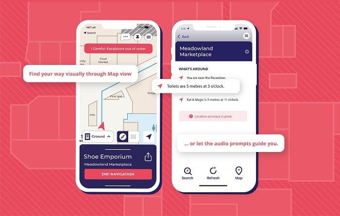
"So we built the app out from being something that just spoke to you, and we put in map views, and then we built wheelchair accessible routing options," she says, adding the team is currently working on sensory sensitivity add-ons for the app, predominantly for people on the autism spectrum.
The 'Bindi' in the name is derived from the words 'be independent', which is what Wright wants to help all users achieve by using it.
"The first time we installed in a shopping centre, the chair of Blind Citizens Australia put out a tweet saying something like 'no longer is blindness an excuse not to buy an anniversary present.' I thought that was hilarious," she says.
"We want everybody to live their lives with dignity, and not have to ask strangers where the toilet is and how the toilet flushes."
Any founder must ask themselves about the competitive threats to their idea, and for a business model like this, the first question most people would ask is: Would this be easy for Google Maps to implement?
"No, not at all," Wright replies. "For a few reasons."
"Google relies on GPS, so that means that as soon as you lose line of sight to the satellites, there is no localisation. That can work okay for somebody who’s sighted - if I gave you a floor plan of a shopping centre and you can work out that you’re next to Woolworths, from that map you can work out where to go to.
"But we can locate you to one or two metres in space indoors which is particularly important for somebody with a disability, but it’s very convenient for everybody who doesn’t."
After starting in early 2017, BindiMaps was ready to launch the commercial product at the end of 2019, just in time for the outbreak of COVID-19. The company managed to secure a couple of shopping centre clients before the pandemic led to them all being shut down, but even when that happened the only choice was to turn a negative into a positive.
"We were like ‘there’s no one in your shopping centres so we can go in and do the mapping and we won't be disturbing anyone'," says Wright.
"We do a lot of work with office buildings – Brookfield, CBRE - and we found that when people came back from COVID, a lot of office buildings had changed; they had downsized their spaces, nobody knew where anything was, and that was one thing that BindiMaps helps with everybody.
"If you have a meeting in a particular office meeting room, you'll get sent a Bindi link; the same way that you'll get a meeting invitation and you’ll get given the building, we give that granular information."
She says it is the property owners who pay for the service, with current customers including Vicinity Centres (ASX: VCX), Mirvac (ASX: MGR), Stockland (ASX: SGP), KPMG, Brookfield Properties, St Vincent's Health Australia and Vision Australia.
"There are no sign-ons, no log-ins, and we don’t collect your personal data. The app will always be completely free for users," Wright affirms.
"People with a disability tend to be in our LSE (low socio-economic) community – not all of them obviously, but we don’t want to be putting additional costs on them. We say to building owners, 'you already provide lights, signage, Braille and ramps, and this is just another level of customer service that you provide'.
"We've got about 115 separate locations. We're doing a roll-out at the moment – we’ve got KPMG, Ernst & Young, we’re working with Charter Hall, CBRE, so it’s exciting for a very small team," she says, noting there are currently around 22 staff employed by the startup.
BindiMaps on a global flight path
BindiMaps is about to embark on a new funding round, expected to be worth millions of dollars, to work on its international expansion ambitions, most likely starting in Singapore as a "test bed".
"That's the second highest aging population in the world after Japan. They actually like the elderly, and it's the elderly who are most likely to obtain a disability, and Singapore is a technically savvy and indoor country," Wright says.
But it was even prior to putting global plans in the works that BindiMaps was approached by the EU to participate in a worldwide tender for the DANOVA project, an alliance of major European airports, seaports and train and bus hubs in the Danube region, aimed at providing the right technology for audio navigation for people with low vision and blindness.
While for many Australian startups the first international moves are likely to be in the US, the UK, New Zealand or Asia, in BindiMaps' case the first overseas implementation was in Budapest International Airport in Hungary late last year.
The BindiMaps app will guide passengers using accessible audio, text or map directions from arrival at the airport, through to registration at check-in counters, security checkpoints and boarding gates.
"We’ve always known how crucial it is that everyone can navigate complicated spaces independently, and the fact that we were chosen as part of a worldwide tender shows that other major organisations around the world are beginning to agree with us," Wright said at the time.
“It’s also a major milestone for BindiMaps, representing the first step in our expansion into Europe and beyond."
She clarifies that because of the way the design model is set up, establishing BindiMaps overseas does not require a large footprint on the ground.
"We actually rely on buildings' own CAD drawings, so we don't need to do the physical mapping. We try to make it as easy as possible so you don't have to go in with the Lidar (Light Detection and Ranging) and do all the mapping," she says.
"More what we'll have in-country is the customer success team. How fast things change...especially in shopping centres. Tenancies roll over all the time, and it’s very easy for maps to go out of date. We actually pride ourselves on our customers' success in that they are very good at keeping everything fresh and relevant."
The startup also received global recognition close to a month ago when it was awarded the title of 'Global Champion' in the category of 'Smart Settlements and Urbanisation' at the EU and UN’s World Summit Awards (WSA) in Pueblo, Mexico.
The WSA program was born out of the United Nations’ World Summit for Information Society, which was set up to see how tech can change the world and help the UN’s Sustainable Development Goals (SDGs).
The solutions presented focused on issues from across the world: unbridling access to citizen engagement around government and governance in Nigeria; creating immersive, multi-sensory experience of Mexican art; monitoring forest via space observation in Lithuania; transforming ordering logistics for small retailers in Namibia; and more.
)