)
South-East Queensland is preparing to shut down later today as Cyclone Alfred bears down on Brisbane and the region braces for landfall in the early hours of Friday morning.
Translink has announced that public transport services across the region will cease after last services this evening until further notice, bringing the region and its population of four million to a grinding halt.
Some bus and ferry services have already been suspended while schools across the south-east and in affected areas of northern NSW will also be closed from tomorrow, along with most businesses.
While Brisbane Airport remains open for now after it was announced that Gold Coast Airport will close this afternoon, travellers have been urged to check with their airline carriers for any potential cancellations should they arise.
The City of Gold Coast has today issued an alert for everyone in the city to “take shelter at home or in a safer place by 6pm” which is when the risk of destructive wind gusts and significant flooding is expected to start impacting the Gold Coast. Logan City has just issued a similar notice.
“If you have been told to evacuate or you do not feel safe in your home, ensure you are in a safer place by 6pm, ideally with family or friends,” says the city-wide alert.
“Evacuation centres should be a last resort - shelter with family or friends first. If you are not in a flood risk area, your best option is to shelter in your home.”
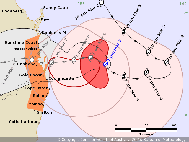
By noon today, Queensland time, Cyclone Alfred was 345km east of Brisbane bearing west at a rate of 16kmh.
The category two cyclone was generating winds of 95kmh near its centre and gusts of up to 130kmh, but destructive wind gusts of up to 120kmh are expected to develop along the south-east Queensland and northern NSW coast between Double Island Point and Grafton from later today.
The wind gusts are expected to persist into Thursday and Friday as Cyclone Alfred makes landfall in Brisbane around 1am (AEST) on Friday morning.
With Brisbane looking the most likely destination for Cyclone Alfred to make landfall, authorities have warned that the cyclone’s southern tail will wreak the most havoc, putting the Gold Coast and Tweed Coast in the firing line.
The Bureau of Meteorology has warned that wind gusts of up to 155kmh may develop from Thursday afternoon.
A dangerous storm tide may occur along waterways with tides likely to rise significantly above the highest high tide mark leading to damaging waves and potentially dangerous inundation.
The bureau has also warned that heavy to locally intense rainfall may lead to dangerous and life-threatening flash flooding late on Thursday.
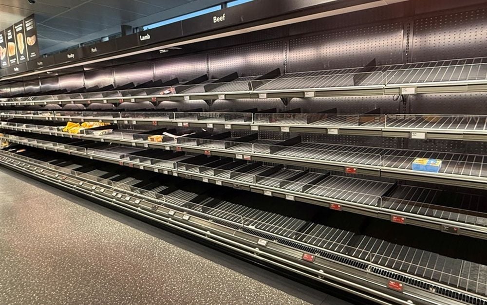
Locals across the region have been preparing for the cyclone in recent days with sandbagging and panic buying emptying supermarket shelves.
Supermarket across the region continue to restock, although disruptions to supply routes are expected as the cyclone’s intensity increases.
Shipping platform Interparcel has warned that businesses shipping to or from affected areas, or relying on Queensland-based fulfilment centres, should brace for longer transit times and increasing pressure on logistics networks.
“These disruptions will not only impact ecommerce businesses but also retailers, wholesalers and manufacturers that depend on timely shipments to maintain operations,” says the company.
“Courier partners are already issuing service alerts, with Aramex, UPS, and other major carriers advising businesses to anticipate longer-than-usual delivery times due to the extreme weather conditions.
“UPS has announced that operations will be suspended for a couple of days, with the possibility of recalling fleets due to intensifying gale-force winds.
“Even businesses outside the direct cyclone zone that ship to impacted regions could face bottlenecks, network congestion, and extended hold times at depots.”
Get our daily business news
Sign up to our free email news updates.
)
)
)
)
)